The World HD

The World HD

By Opicury Software

  • Category: Reference
  • Release Date: 2010-04-01
  • Current Version: 4.7
  • Adult Rating: 4+
  • File Size: 164.35 MB
  • Developer: Opicury Software
  • Compatibility: Requires iOS 12.0 or later.
Score: 4.38056
4.38056
From 247 Ratings

Description

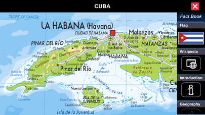
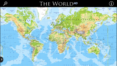
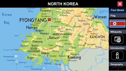
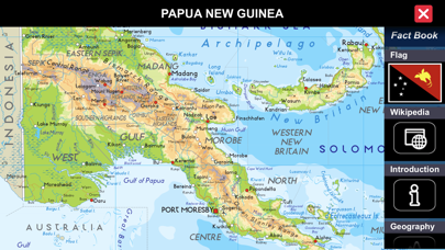
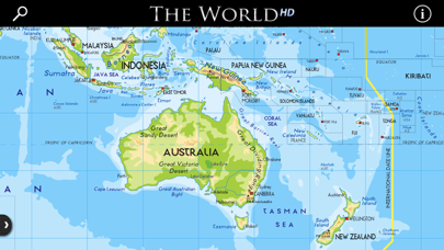
THE PREMIER IPAD ATLAS - with RETINA VECTOR MAPS The World HD is unique in the app store because it includes both a complete set of country maps AND the largest world fact book. These enable it to answer questions which Atlases and fact books cannot: Atlases show you where countries are located, but have very little information about them; fact books tell you about each country, but their maps leave you guessing about where places are located. ___________ HOW IT WORKS ___________ The interface is animated and interactive. Touch a country on the world map and the Retina vector country map opens while the factbook slides onto the screen, each topic neatly organized as tiles along the edge of the map. Touch a factbook tile and it zooms out to reveal detailed information about that topic. Not sure where a country is located? Select it on the drop-down list and The World HD zooms in on it then opens the map and factbook. The zoomable world map is not just the fastest way to select a country it also enables you to visualize and understand entire regions. It is so intuitive and easy to explore that once you get started it's hard to stop! ___________ FEATURES ___________ RETINA VECTOR MAPS ** Includes high-resolution Retina vector maps for EVERY COUNTRY built-in! Unlike the other atlases, these maps remain in focus at all magnifications so you can easily see even the smallest detail. These aren't the CIA maps found in the factbooks, they are used in printed atlases. MORE INFORMATION ** Contains geopolitical and demographic information on 300 countries and regions. NO INTERNET CONNECTION is required ** Except for live Wikipedia content, all data and maps are built-in INNOVATIVE FACT BOOK PANEL ** Presents each section of the fact book as tiles enabling you to quickly find what you need, while keeping the country map in view. HIGHLY ANIMATED INTERFACE ** Responds to your touches and gestures so you can quickly find the information you are looking for. CIA WORLD FACTBOOK ** This trusted source of current country information is built-in for every country, including sections on: introduction, geography, people, economy, communications, transportation, military, and transnational issues. WIKIPEDIA ** View the live, community-written Wikipedia content for each country, island, and remote region within the app. SHOWS YOU where countries are located ** Not sure where a country is located? Select it on the country list and The World zooms to it on the world map and opens the Fact Book Panel DESIGNED FOR YOUR IPAD & IPHONE ** Thoughtfully uses the whole screen to present maps and data

Screenshots

Reviews

  • Map needs updating

    3
    By Allston-Tollcross
    The app is relatively good at what it does, and more convenient on the iPad than some alternatives. The rendering of the maps seems generally rather good, however there seem to be some inconsistencies especially with the political maps. (For instance, the states of Mexico are sharply demarcated but not the states of Australia or Germany or the provinces of Canada.) In addition, the map presently seems to have some outdated information, for instance “Mount McKinley” in Alaska instead of the correct and official name, Denali; also, it draws the International Date Line through, rather than around, the nation of Kiribati.
  • Language

    4
    By ngcnewton
    I wish that we could switch to have commonly used English names for the cities. I use this to increase my knowledge but it is often hard to find the cities, rivers or even small countries as they are only given in the native language.
  • Very Useful

    5
    By ascender review
    Very useful. I don’t care, personally, for the typestyle, but I use the app just about every day for world events.
  • Where’s the rest?

    3
    By MyMusicIsBetterThanYours
    The maps are fairly detailed in terms of countries and cities, but that’s it. Provinces, counties and many bodies of water are not identified. Those that are, aren’t always clear. Yet another map app that leaves me wanting.
  • Solid App at the Right Price

    5
    By .
    Quick to load and access, lots of detail, and no online access required. Definitely going to be my go-to world map from now on.
  • if pilots used this, they’d be lost

    1
    By 70tas
    very limited map detail, no geo-political, and no navigation
  • Finally

    5
    By barely_able
    The atlas I have been waiting for.
  • As an broad view Atlas

    2
    By The Hultster
    This is only good for large generalized maps. If you wish to explore small towns and villages this app is incapable of doing. Only shows largest cities.
  • Has always worked well

    5
    By Larry David Letterman
    Great job.
  • What I was looking for...

    5
    By Keys Doctor
    If you're looking for a flat globe type image that shows all world locations connected, then this will work just fine. I found other maps, but most were sectioned off by continents. This app provides a full connected world view that can be expanded, scrolled across as well as up and down to view how all locations are connected without having to stop and go to a different set of maps to locate an adjoining area.

keyboard_arrow_up