Elevation For Real

Elevation For Real

By homedatasheet.com, Inc.

  • Category: Navigation
  • Release Date: 2009-12-29
  • Current Version: 10.0
  • Adult Rating: 4+
  • File Size: 616.00 kB
  • Developer: homedatasheet.com, Inc.
  • Compatibility: Requires iOS 13.0 or later.
Score: 3.25
3.25
From 4 Ratings

Description

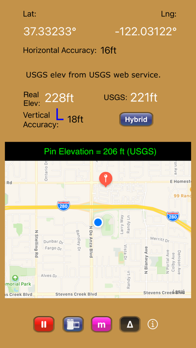
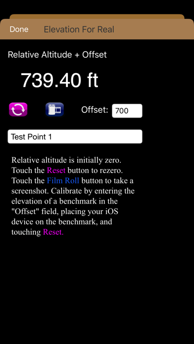
Get real-time elevation from your iOS device's GPS receiver and built-in geoid model. As a bonus, we've also included access to the USGS Elevation Web Service which provides US ground elevation data. You'll be amazed at how, when you have a good view of the sky, Elevation For Real's internally generated elevation converges on the USGS value after just a short time. Outside the U.S., or on iOS devices with non-U.S. region settings, or if the USGS elevation service is unavailable, Shuttle Radar Topography Mission (SRTM) published elevation data is shown between 60°N and 56°S latitude. Here are some more features: - Real-time map which displays your location - Estimated vertical and horizontal accuracy - Spot elevation data displayed by tapping map - English or metric units based on your region setting - Start/Stop button - One touch screenshots - NO Third-Party Ads! - Optional pressure altimeter (in-app purchase). Measure relative altitudes or calibrate to an elevation benchmark. Use indoors or out. Even works in Airplane Mode! Note: your iOS device must be equipped with a barometer to access pressure altimeter functionality. The iPhone 6 and later and the iPad Air 2 and later have barometers. Download Elevation For Real today! Notes: 1) homedatasheet.com, Inc. is not affiliated with USGS. USGS Elevation Web Service is available to the general public online, at no cost. 2) SRTM is provided by geonames.org. homedatasheet.com, Inc. is not affiliated with geonames.org. U.S.-based users should note that, in many instances, the SRTM data is not as accurate as USGS data. All users should note that, in certain locations, the SRTM dataset may be tens of meters or more in error. 3) ***The initial view of this app requires a GPS signal to work properly. A clear view of the sky is needed for GPS reception, and it may take several seconds to get a position fix. Elevation for Real will run on devices not equipped with a GPS receiver and GPS-equipped devices that are not receiving a GPS signal, but any resulting elevation readings will just be the approximate ground elevation at your location, even if you are several stories up in a tall building. 4) ***Any elevation measurements with personal safety or financial implications should be performed by professionals with professional GPS equipment. Elevation for Real is not intended to determine flood hazard. Consult a licensed professional in your jurisdiction, such as a surveyor or engineer, when dealing with flood risk.

Screenshots

Reviews

  • Great

    5
    By Trainman2
    I've only use this app a short time for search & Rescue. It's a great app. Works very well.
  • Accurate and it does the job.

    5
    By Ned Scuba_bk
    I use this app at construction sites to verify the elevations of deferent areas and it does the job. Thank you.
  • Excellent

    5
    By MAF
    The elevation reported is very accurate. Also, unlike most other elevation apps this one displays an uncertainty tolerance and identifies the digital elevation darabase it uses.
  • Accurate

    5
    By revNickname41
    This is the most accurate elevation app I have found on the App Store.
  • Great app

    5
    By Novellen
    What a great little app! We're house hunting and want to know the elevation of the houses we look at. This does the trick perfectly. We can tell which homes are out of the tsunami danger zone. Just what I wanted when I got the app.
  • V2.4 (current free version) works perfectly in Marin County, California

    5
    By Michael SF
    This app did exactly what I wanted during my walks between sea level and 2750 ft elevation around Marin County in the San Francisco Bay area. Within half a minute or so, it told me what my elevation was, with estimates from both the iPhone 3G GPS and the USGS database, indexed by latitude and longitude. With longer periods of sampling, the two estimates generally converged within 20 ft or so, even on mountain paths. It is really a terrific addition to the phone, complementing the main feature that the built-in Maps for iPhone lacked.
  • Good app

    4
    By Metdoc1
    I just wanted an app that could tell me my current elevation. It did exactly that. Ran fine I have a Verizon iphone4.
  • Super!

    5
    By Wingingit
    Hey, these guys are super in creating this app. This is not a toy. This is a pro-consumer app. Great support. Lots of uses and a great learning tool for school kids and curious folks.
  • Great app, can't beat the price

    5
    By DJRobX
    I was looking for a simple app to show elevation at my current location and this does that nicely. Not super accurate, but wasn't expecting that. Has a very nice user interface.
  • Well thought out app that does the job quickly

    5
    By Fgrider
    I started this app for the first time indoors when the shades were closed. It still worked! They also explain why most other altimeters for the iPhone don't work properly. Nice.

keyboard_arrow_up