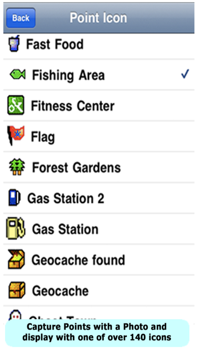
Enjoy hours of outdoor fun with PathAway guiding, and tracking your way! Mark points of interest, with details or photos at those special spots along your route! Navigate with free online maps that are downloaded on-the-fly and are cached on the device so they're available when there is no data coverage. Never get lost again, and track your route so you can explore it again. Whatever your outdoor adventure is you can use maps that will guide you, and track where you are so you can easily get home, or use this route again on your next trip out. PathAway is useful for activities such as hiking, boating, sailing, aviation, off-road driving, cycling, touring, Geocaching, rally racing, motorcycle touring, running and athletic training, ballooning, fishing, hunting, paragliding, mountain climbing, ultra-light flying, canoeing, snowmobiling, scuba diving, or outdoor education, or any application where location is important. Check out some of these great reviews: ***** Perfect for Offroad Navigation! - By Walln - Austria Absolutely great for the off-road navigation. ***** Best GPS navigation App for iPhone Aung Mau - Thailand There are lots of GPS navigation applications for iPhone but if you really start using this PathAway, you will know the difference at once and will love it. All features are there except importing customized maps (which is in the Express Version). This app is the best GPS Navigation App for iPhone. **** Works Great! - Aorosa - on iTunes App Store USA I used to have Pathaway in other devices. Excellent program now in iPhone! **** Fantastic App for the backcountry - KootenyGuy - Canada * Read full reviews at http://pathaway.com * Features: - Tried and tested software base developed with user feedback over the last 14 years. Maps: - Use online maps from OpenStreetMap, OpenCycleMap, USGS Topos; - Maps are downloaded on-the-fly as you travel; - Maps can be cached for off-line use when connectivity is not available; Tracking (Breadcrumb): - Log your travels for later analysis, or use as a route to follow next time out. - Pause and continue track timer for precision timing; - One-touch "BackTrack" feature to find your way home after recording your way out; - Manage and Edit Track logs and track points; - Store as many Track logs as you like for use later. - Share your location with others and monitor each other in the app. Points: - Capture points, describe by name, icon, description, photo; - Over 100 icons to choose from; - Manage and Edit Points; - Organize your points by creating multiple Points Databases; Navigation: - Navigate directly to a single point or follow multi-point routes; - Create navigational routes simply by marking the route on the map; - Alarms to notify you when you've strayed off your route, or nearing a marked point; - Uses built-in magnetic compass for slow speed directional location. Great for Geocaching when you’re trying to pin-point a cache. - View navigational information on a customizable dashboard; - Map View or Compass and Info Views; - Multiple coordinate grid and datum display including lat/long, UTM, OSGB, MGRS, MGA, GGRS87, Warschauer, Localized Grids for Austria, Germany, Quebec, Sweden, Switzerland, Israel. - Import/Export GPX, KML, KMZ, and PathAway delimited files. NOTES: - External GPS (like Bluetooth GPS) is required to obtain location for iPad Wifi. - For advanced features and support for custom maps (.PRC, BSB/KAP), upgrade to PathAway PRO via in-app upgrade.