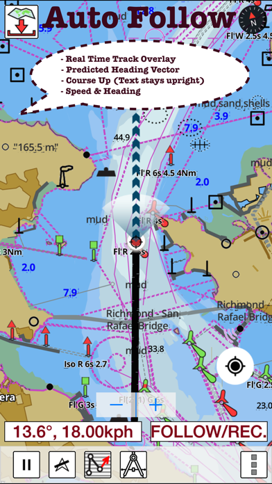
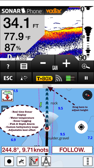
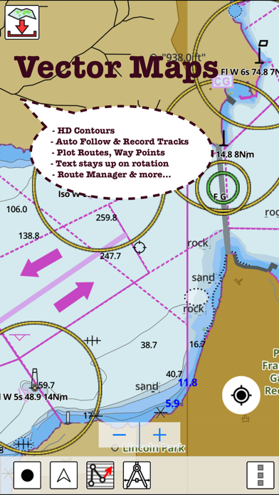
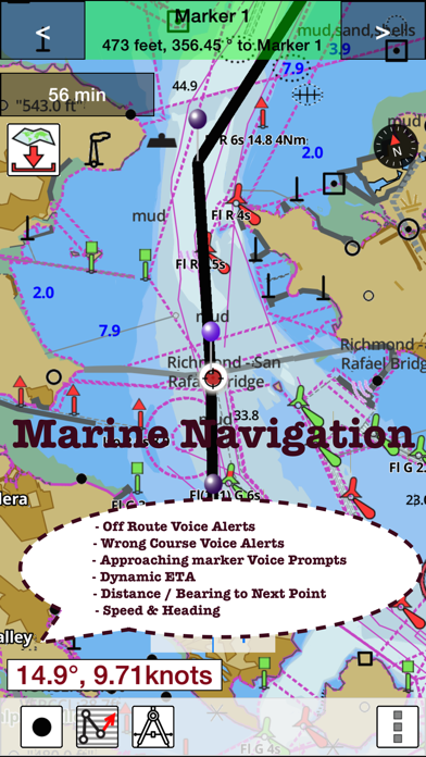
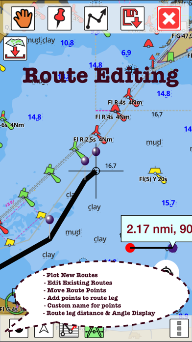
This App offers access to CHS marine vector & raster charts. First marine GPS app to have route assistance with Voice Prompts for marine navigation. You can create new boating routes or import existing GPX/KML routes. It supports Nautical Charts course up orientation. Includes Tide & Currents prediction. (Includes coverage for Trent Severn Waterway incl. lake Simcoe etc.) ►FEATURES √ Beautiful and detailed Hardware/GPU accelerated vector charts (text stays upright on rotation) √ Long press to query the details of Marine object (Buoy, Lights, Obstruction etc). √ Customizable depth(Ft/Fathom/Meter) and distance units (km/mi/NM) √ Customizable Shallow Depth. √ Record tracks, Autofollow with real-time track overlay & predicted path vector. √ Voice Prompts for marine navigation (requires GPS ) √ 1ft / 3ft depth contour maps for anglers for selected lake maps. √ Supports GPX/KML for boating route editing/import. √ Tide & Currents prediction. √ Seamless chart quilting of marine charts √ Enter or import Waypoints. ► MAPS The maps include coverage of Pacific Coast, Central Canada(incl. Great Lakes, Trent Severn Waterway, Ontario Lakes), Atlantic coast derived from CHS data. ►ROUTE MANAGEMENT / TRIP PLANNING √ Create New Route/Edit Existing Routes √ Move Points √ Add points to an existing route leg √ Delete / Rename points √ Import GPX, KML & KMZ files √ Plot/Edit Routes √ Enter Waypoints √ Share/Export Routes, Tracks & Markers √ Reverse Routes ►GPS FEATURES √ Auto Follow * Real Time Track Overlay * Predicted Path Vector * Course Up (Text stays upright) * Speed & Heading √ Route Assistance With Voice Prompts * Prompts when approaching a boating route marker * Continous distance and ETA updates * Alerts when sailing/boating off route * Alerts when boating in wrong direction √ Record Tracks ►TIDE & CURRENTS * For US, Canada, UK, Germany & New Zealand * High/Low Tides * Tidal Current Prediction * Active Current Stations ►Instrumentation √ Marine AIS & (NMEA AIS and GPS over TCP/UDP) √ Wind direction & Speed,Sonar depth,Water temperature ► SHARING * Share tracks/routes/markers on Facebook & Twitter * Export tracks/routes/markers as compressed GPX files. Sample Nautical Charts ►Rainy Lake and Lake of the Woods ►Quebec to Anticosti Island West ►Gulf of St. Lawrence South ►Ontario Lakes ►Trent-Severn Waterway ►Labrador Coast ►Lac Saint Jean ►Rideau Canal - Ottawa River ►Georgian Bay ►Newfoundland East and South ►Great lakes Canada and St. Lawrence river ►Lakes and Rivers in Manitoba and Saskatchewan ►Lakes and Rivers of British Columbia ►Pacific Coast - Vancouver Island East & West - Haida Gwaii ►Lakes around Georgian Bay ►Gulf of St. Lawrence North - Newfoundland West ►Alberta Lakes ►Nova Scotia South - Bay of Fundy Vancouver Island Ile de Vancouver, Juan de Fuca Strait Queen Charlotte Sound Strait of Georgia, Southern Portion Partie Sud Lake Ontario Lac Ontario LAKE SIMCOE Strait of Georgia, Central Portion Partie Centrale BIG CHUTE MARINE RAILWAYS BER ROULANT Strait of Georgia, Northern Portion Partie Nord Georgian Bay Baie Georgienne Strait of Georgia, Central Portion Partie Centrale North Pender Island to a Thetis Island Thetis Island to a Nanaimo Juan de Fuca Strait to a Strait of Georgia Howe Sound Active Pass Nanaimo Harbour and et Departure Bay LAKE ROSSEAU AND/ET LAKE JOSEPH Haro Strait, Boundary Pass and et Satellite Channel Approaches to Approches a Vancouver Harbour Vancouver Harbour, Western Portion Partie Ouest Telegraph Harbour and et Preedy Harbour Ganges Harbour and et Long Harbour Dodd Narrows to a Flat Top Islands Baynes Sound Approaches to Approches a Sidney Desolation Sound and et Sutil Channel Porlier Pass Fraser River Fleuve Fraser, Strait of Georgia Mitchell Island Fraser River Battery Disclaimer: Continued use of GPS running in the background can dramatically decrease battery life.